Hurricanes dominated the news over the last weeks. For hurricane Irma, MIT’s Urban Risk Lab launched a pilot of their platform RiskMap.us, which was build to help people in need. For the Broward County in Florida, MIT created a platform that made it possible to get a better overview of the passing hurricane. They enabled residents and rescue workers to add information about their situation through social media.
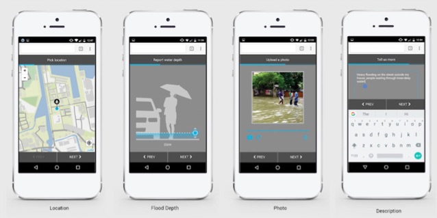
Residents could contact MIT’s Risk Lab by using Twitter, Facebook or Telegram. After that, a chatbot sends a link back to the residents, which leads to a website where they have to fill in some information about what damage the hurricane had done. Residents fill in their location, add a photo with description and provide information about how high the water is rising. This allowed the MIT’s team to create a risk map of the area showing in real-time what parts of the area were flooded and how fast the water was rising in some specific locations. Using this information, rescue workers could prioritize their efforts and therefore, use their people more efficiently.
In February of this year, the RiskMap has already been tested in Indonesia. 300.000 users made reports and visited the website. Also, integration in the Uber app allowed drivers to avoid the flood. Another version is being developed for India, which will provide support during the monsoon season there. Besides flooding, MIT tries to build platforms for other causes as well. For example, after the earthquake in Mexico, they set up a platform to connect people in need with volunteers. People could ask or offer things like medical assistance, food and water, which would show on a map, so people nearby could provide support.
Crowdsourcing is used for various reasons. It is really interesting to see in what directions you can take it and for what it can be used. Especially, how technology and crowdsourcing are able to be a helping hand in situations like this already and how much more it is able to do in the future. Have you heard of any other examples?
Sources:
http://news.mit.edu/2017/map-real-time-crowd-sourced-flood-reporting-hurricane-irma-0908
https://www.theverge.com/2017/9/9/16280250/mit-urban-risk-lab-riskmap-hurricane-irma-real-time-crowdsource-flood-reporting
http://news.mit.edu/2017/manos-a-la-obra-crowdsourcing-aids-mexican-earthquake-victims-0924
Image: https://www.nasa.gov/image-feature/hurricane-irma