Last Christmas I was on my dream trip to New York. Everyday I use google map navigation and a weather forecast app to avoid my trip being messed up by getting lost or bad weather. I didn’t realize that I should have sent a Christmas greeting to the satellites who actually guaranteed my amazing trip.
Probably because we had it for so long that we almost take what satellites do for granted, especially after we enter this internet booming age. Imagine what will happen if internet breaks down one day. Things might become much less convenient; students have to go back to the libraries; album shops, shopping malls and book shops will come back, etc. Then what would happen if all satellites stopped working? Would it be severer than the internet stop? You, as an individual from the young generation, might say “Of course not. I don’t watch TV, I use whatsapp and facebook instead of SMS and phone calls, why should I care about those satellites?” Well, the answer can be totally the other way around from a military officer, a transportation company, a logistic company or a multinational company. Why? Let’s quickly go through what do satellites do for us every day.
Satellites are manmade objects put into orbit. They send signals to television, telephones. Navstar Global Positioning Systems (GPS) and weather forecasting are all based on satellites. They seem very common to your daily life, but you might think you can live without them right? However, the failure of secure satellite communications systems left soldiers, ships and aircraft cut off from their commanders and vulnerable to be attacked. Without satellites, people who works in their offices in Tokyo, Shanghai, London and New York found it difficult to talk to colleagues who work at the other side of the world. Farmers relied on forecasts for planting, spraying and harvesting. The aviation industry needed forecasts to make decisions that would affect the lives of passengers. The rapid communications systems that tied the world together were unravelling. It seemed as if the Earth was getting larger. But what else can satellites do? The answer is, a lot!
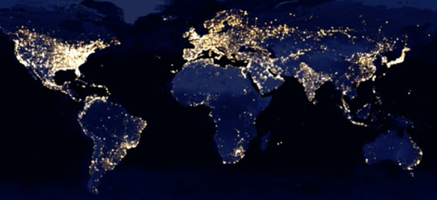
In 2016 May, William Gadoury, a boy at age 15 discovered a lost Maya city by comparing star charts with satellite images. Another example of involving satellite information in research is the poverty project from Stanford University. A group of researchers are tracking the poverty distribution and development level of five poor African countries. Places that brighter at night are usually more developed. And by analyzing the roads, urban areas, waterways, farmland and so on to predict the wealth level of that area. They found this method is better done than any existing approaches, since it is cheaper, more accessible and more objective than the local government survey. The accurate poverty analysis helps to distributes funds more efficiently, and enact and evaluate policies more effectively.

Apart from that, satellite images are recently also used in financial analysis. A company called Planet Labs Inc. has launched a small constellation of what it calls “cubesats” that can deliver much more frequent imagery of economically sensitive spots than traditional satellites. A company Orbital Insight Inc. has mined satellite imagery for trading tips for hedge funds. This analysis includes revenue predictions for big-box retailers such as Wal-Mart Stores Inc. and Target Corp. based on changes in the number of cars in their U.S. parking lots, or forecasts for oil inventories based on the height of floating lids in oil tanks in the U.S. Mr. Crawford, a former Google executive who founded Orbital, said “The most excitement we’ve heard from Wall Street clients is understanding markets like China or places in the world that are not as transparent.”
An up to date innovation of satellites is that China launched world’s first quantum science satellite on 16th August. The main goals of Quantum Experiments at Space Scale(QUESS) project will be to demonstrate quantum key distribution (QKD) between the satellite and two stations on the ground – the Nanshan 25 m telescope at the Xinjiang Astronomical Observatory in western China and the Xinglong Observatory in Yanshan, around 200 km south of Beijing. A quantum key is a string of ones and zeros, representing the quantum states of particles. These can be used to encode and decode messages, which would be secure from eaves droppers. Although there is still a long way to go, would it be a solution for the telephone tapping
In which areas can we make use of the satellites information? What do you think?
http://www.bbc.com/news/blogs-trending-36259047
http://www.bbc.com/future/story/20130609-the-day-without-satellites
http://www.wsj.com/articles/satellites-hedge-funds-eye-in-the-sky-1471207062


